


12:30 18th November
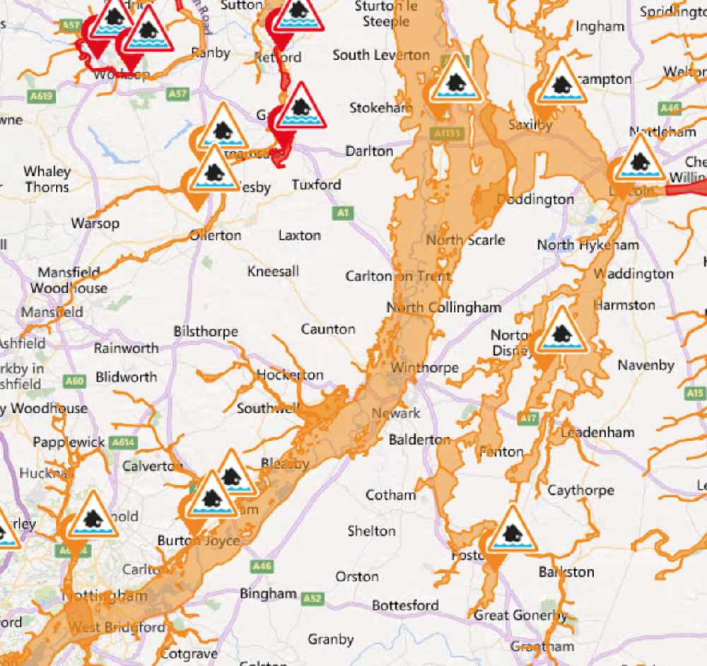
Flood Warnings remain in place in Collingham and Girton.
River levels remain high but steady at the Torksey river gauge as a result of spring tides coinciding with high river levels. Consequently, the risk of flooding remains. The area most at risk is Collingham, Girton, Carlton on Trent and Beck Cottage. No further rainfall is forecast over the next few days, but the Environment Agency expect river levels to remain high until tomorrow morning, Tuesday 19th November.
The A617 at Kelham remains closed despite water levels dropping, this is due to water running off nearby fields.
A Flood Alert remains in place for communities living close to the River Trent. These include Caythorpe to Hoveringham road and cellars of low lying properties at Cavendish Bridge. River levels are finally falling but a flood risk is still posed.
The Flood Warning for the area of Tolney Lane has been removed and is no longer in force.
 12:05pm 17th November.
There are currently no change to yesterday’s update at 8pm.
River levels will remain high for a further 24 hours with a risk of flooding to areas highlighted.
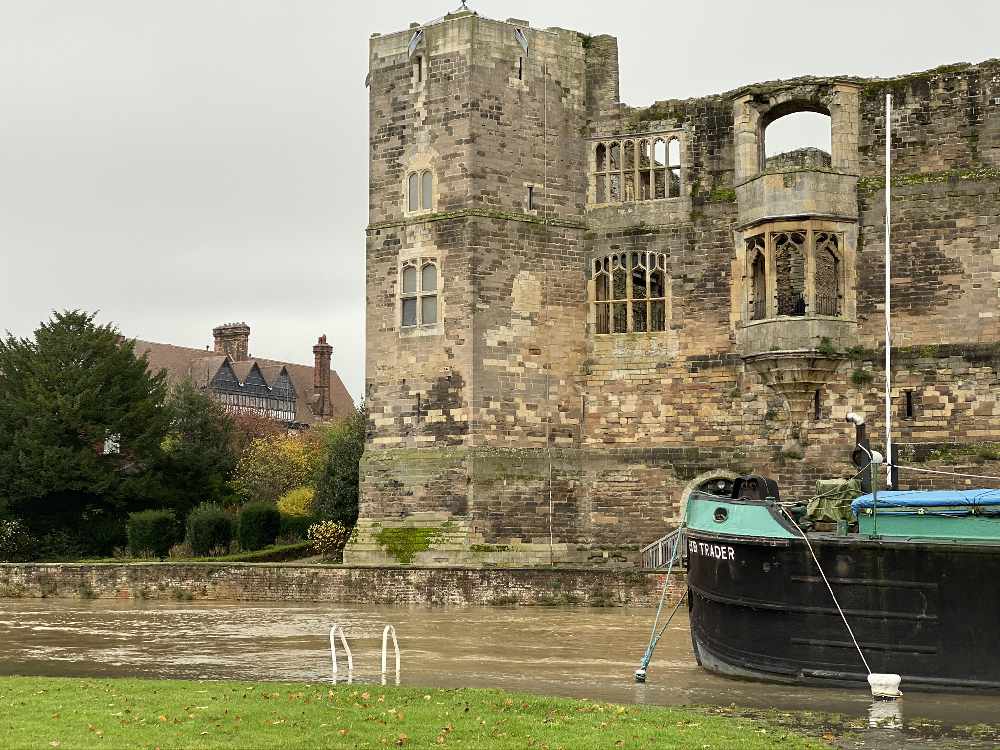
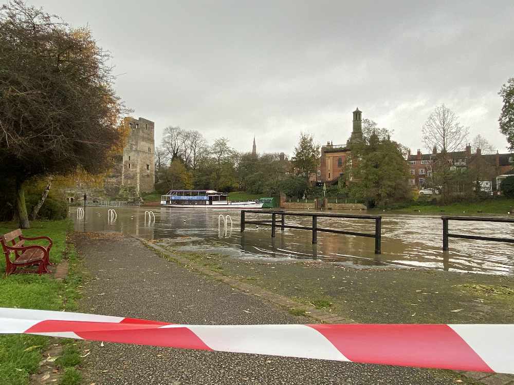
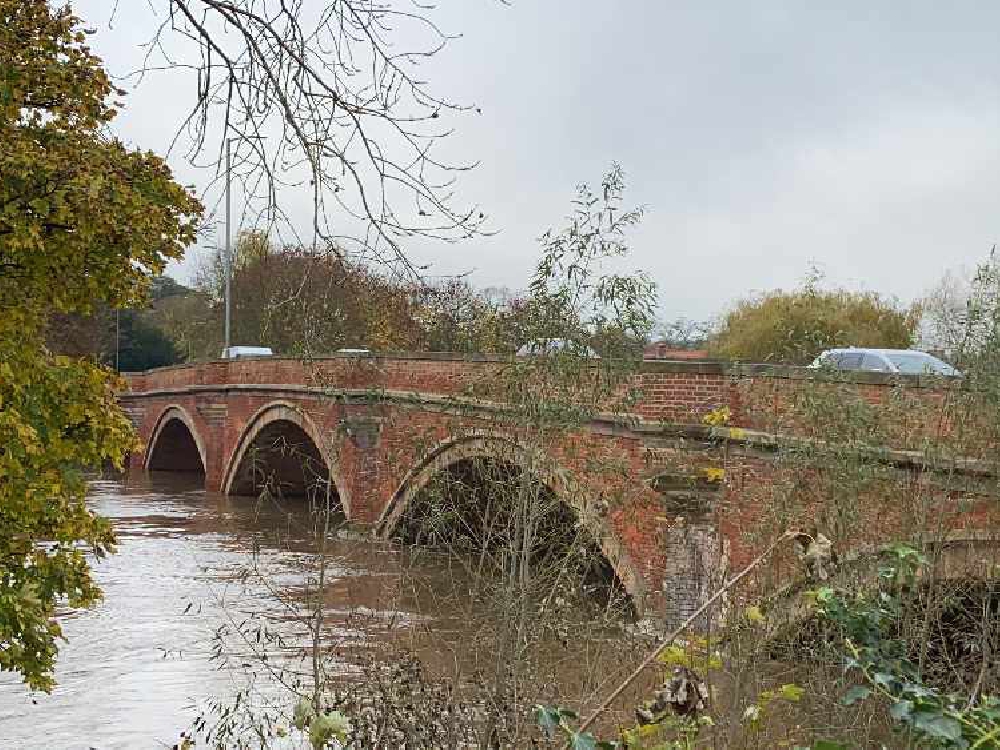
Photo - Saturday 16th 1:45pm
8pm 16th November
Newark:
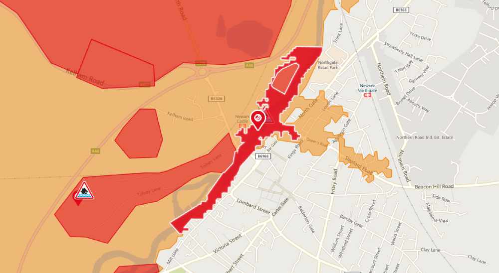
River levels are high but steady at the Farndon river gauge as a result of heavy rainfall. Consequently, the risk of flooding remains. Areas most at risk are Tolney Lane Caravan Site and riverside marinas in Newark. Further light rainfall is forecast over the next 24 hours. River levels are expected to remain high until tomorrow.
River levels at Newark Castle at 145pm 16/11/2019
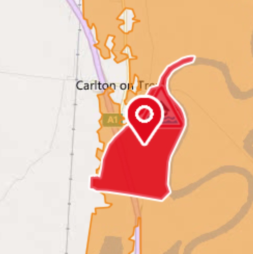
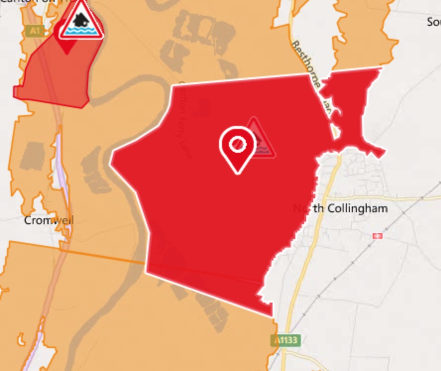
Carlton on Trent & Beck Cottage, Collingham and Girton:
River levels are high but steady at the Torksey as a result of high spring tides coinciding with high river levels. Consequently, the risk of flooding remains. Areas most at risk are Carlton on Trent including Beck Cottage. Further light rainfall is forecast over the next 24 hours. River levels are expected to remain high throughout the weekend
7.45pm 13th November 2019
Updated list of closed roads according to NSDC:
A1 Southbound slip road off to Fernwood / Balderton
Nottingham Road near the Minster School in Southwell
A617 near Kelham Bridge
A612 in Upton
A617 in Kirklington
A617 in Rainworth
Caunton – Ford Lane
Farndon - Chapel lane
Newark – Tinkers Lane
Hockerton – Main Road
Lambley – Main Street
Oxton – Blind Lane
Balderton – Staple Lane
5.10pm 13th November 2019
Current road closures in place due to flooding:
A1 Southbound slip road off to Fernwood/Balderton
Caunton - Ford Lane
Farndon - Chapel Lane
Newark - Tinkers Lane
Hockerton - Main Road
Southwell - Nottingham Road (off Westgate past Minster School)
Lambley - Main Street
Oxton - Blind Lane
Balderton - Staple Lane
In Upton, the tree that was blocking Main Road has been cleared - but reports of standing water on this road.
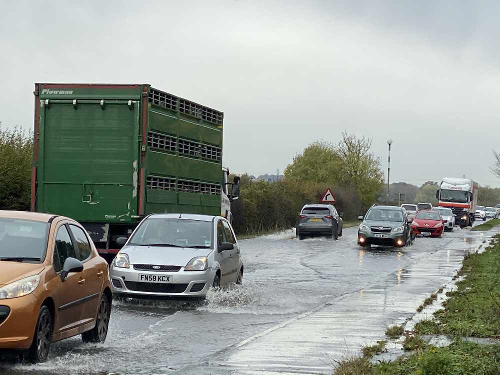
The following roads are currently open but reports of standing water on the A46 from Bingham to Newark, East Stoke Crossroads, A617 from Rainworth through to Newark, A612 through Burton Joyce and A52 from Radcliffe to A46. As a result, all routes around Newark are busy and slow moving.
Broken down vehicles and flooding reported on Staple Lane.
Update on train service around Newark, trains are running at reduced speeds and passengers are warned to expect delays.
⚠️🌧️#UKRain - Trains are now able to run between Matlock and Derby and between Nottingham and Newark Castle.
— National Rail (@nationalrailenq) November 14, 2019
Trains are unable to run between Derby and Nottingham. #Spondon and #LongEaton are not being served.
ℹ️https://t.co/o2IiWy9qbO
4:18pm 13th November 2019
New Flood Warnings
Cocker Beck Lowdham:
As a result of persistent heavy rainfall river levels are still rising. Consequently, flooding of property, roads and farmland is possible this afternoon, 14/11/2019. Areas most at risk are Lowdham Main Street, and Station Road, including Merevale, and Limetree Gardens.
River Maun at Edwisntowe and Ollerton:
Flooding of property/roads and farmland is expected/possible between 15:00 and 18:00 today, 14/11/2019. Areas most at risk are Edwinstowe and Ollerton. We expect river levels to remain high until 22:00 tomorrow 15th November
River Maun at Sherwood Forest Caravan Park near Kings Clipstone:
Flooding is imminent. Areas most at risk are the Sherwood Forest Caravan Park and properties near Kings Clipstone. We expect river levels to remain high until 22:00 on 15/11/19.
Plea from Notts Fire and Rescue for Motorists to avoid driving through deep water:
⚠️Please take extra care driving in this weather, we have been called to a number of vehicles trapped in floodwater. Don't risk it.⚠️🌊🌧️🚗 pic.twitter.com/tR3SJSMhqy
— Nottinghamshire Fire and Rescue Service (@nottsfire) November 14, 2019
"There will be a lot more rainfall over the next 12 hours so the risk of further flooding remains and we all need to be ready and prepared for this"
Nottinghamshire Police are warning people to be mindful of local flooding advice, as officers continue to monitor rising river levels following the recent wet weather.
The force has been helping to keep people, their homes and other property safe as part of a multi-agency response to the flooding, which has affected communities across the county – including most severely in Mansfield, Newark and Worksop.
Inspector Rob Taylor, of Nottinghamshire Police, said: "There will be a lot more rainfall over the next 12 hours so the risk of further flooding remains and we all need to be ready and prepared for this.
"All blue light services are in contact with each other, as well as the Environment Agency and Met Office, and we’re monitoring rainfall and how the small tributaries are responding.
"The advice to residents remains to act quickly if their home is affected by flooding and go to a safe place, whether that is with family and friends or a rest centre.
"We’re continuing to monitor the impact of the wet weather and are working closely with our partners to help minimise the impact on the communities we serve.
"We’re urging people to take reasonable precautions to protect themselves and their property by ensuring they are seeking out updates about flooding in their area, as well as taking extra care when they are either driving or walking through areas of standing area.
"With water on the roads and temperatures due to fall overnight, we’re also warning drivers to take extra care on the county’s roads.
"Please avoid driving on roads near low lying land near to rivers, check for road closures in your area, please don’t ignore road closure signs and do not unnecessarily walk or drive through flood water."
2.30pm 13th November 2019
A1 Sliproad Southbound at Fernwood
A1 Southbound slip road at Fernwood/Balderton turn off has been closed due to flooding. Motorists are asked to avoid the area.
12:30pm 13th November 2019.
Carlton on Trent and Beck Cottage.
A Flood Warning remains in place today Wednesday 13th November for Carlton on Trent and Beck Cottage.
River levels are rising at the Torksey river gauge as a result of high tides coinciding with high river levels.
As a result of this flooding is expected on the high tide from 09:00 this morning and subsequent high tides until Friday 15th November 2019.
River levels are expected to remain high until the weekend and further rainfall is expected tomorrow throughout the area.
Flood Alerts remain in place around the surrounding area of Carlton on Trent.
05:30am 10th November 2019
Newark Riverside properties, Farndon, Tolney Lane, Kelham and Sugarbeet area:
Water levels remain high but are are starting to fall. Further rain is forecast on Monday 11th of November and river levels are expected to rise again, however the new predicted levels do not currently pose a flood risk concern.
Collingham, Girton and Carlton on Trent:
A combination of high river levels at Torksey and high tides mean the risk of flooding still remains especially during high tides until tomorrow Monday 11th November.
10:18 pm
Collingham & Girton:
River levels have risen further as a result of high tides. Flooding is expected from the next high tide, approximately 08:00am on Sunday 09/11/2019. Areas most at risk are Collingham and Girton. River levels are expected to remain high until for approximately 48 hours. Advice from the Environment Agency is to move valuables and possessions to a higher location.
Farndon:
River levels are forecast to rise further at Farndon as a result of the recent heavy rainfall. Consequently, flooding of property, roads and farmland is possible tomorrow morning Sunday 10th October. Areas most at risk are Farndon, including Wyke Lane, Marsh Lane, Farndon Road and Dorner Avenue. Further rainfall is forecast.
Newark Riverside Properties:
Flooding of property, roads and farmland is possible now and until early hours tomorrow morning. Areas most at risk are Newark Riverside Properties. Further rainfall is forecast. River levels are expected to remain high until early hours of Sunday 10th November 2019.
Tolney Lane and Riverside Marina;
Flooding of property, roads and farmland is expected to begin now and until early hours tomorrow morning, 10/11/2019. Areas most at risk are Tolney Lane Caravan Site and riverside marinas in Newark. Further rainfall is forecast. River levels are expect to rise until tomorrow morning, 10/11/2019.
Sutton on Trent:
Sutton on Trent remains a flood alert not warning. River levels have increased and will remain high. Flooding of roads and farmland is possible today Saturday 09/11/2019. Areas most at risk are Church Laneham to Rampton Road, Collingham, Sutton on Trent, North Clifton, Torksey and Lea.
Who do I call in the event of flooding?
If you are in a flood risk area make and keep a flood kit:
Store it someone that is quick and easy to get hold off and make sure children are aware where it is stored.
A flood kit should include some key essentials:
- Important personal documents
- Torch
- Battery-powered or wind up radio
- Rubber gloves
- First aid kit
- Baby essentials
- Important phone numbers
- Disposable camera
- Wellington boots
- Waterproof clothing
I think I need sandbags, who do I call?:
It is not the responsibility of Newark & Sherwood District Council (NSDC) to provide sandbags to owners of flooded, or properties with potential to flood. NSDC have no legal obligation to supply sandbags either. They can however be issued to vulnerable persons and other circumstances.
Full details and more can be found on their website here
My property is flooded, what should I do?
Details on how to deal with flooding in your property can be found here
Picture: The A617 at Newark Rugby Club 30 minutes prior to it closure.
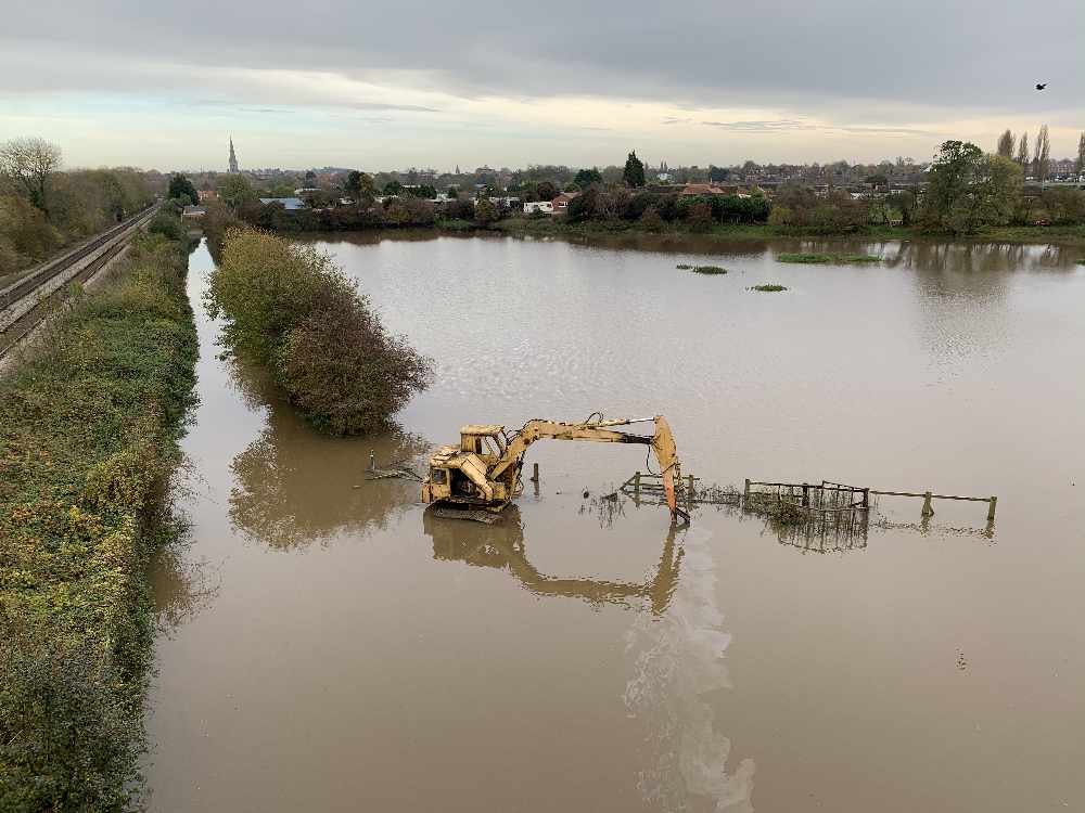
Picture :The lonely plant - Machinery abandoned as water levels started to rise at lunchtime along the A46 at Newark
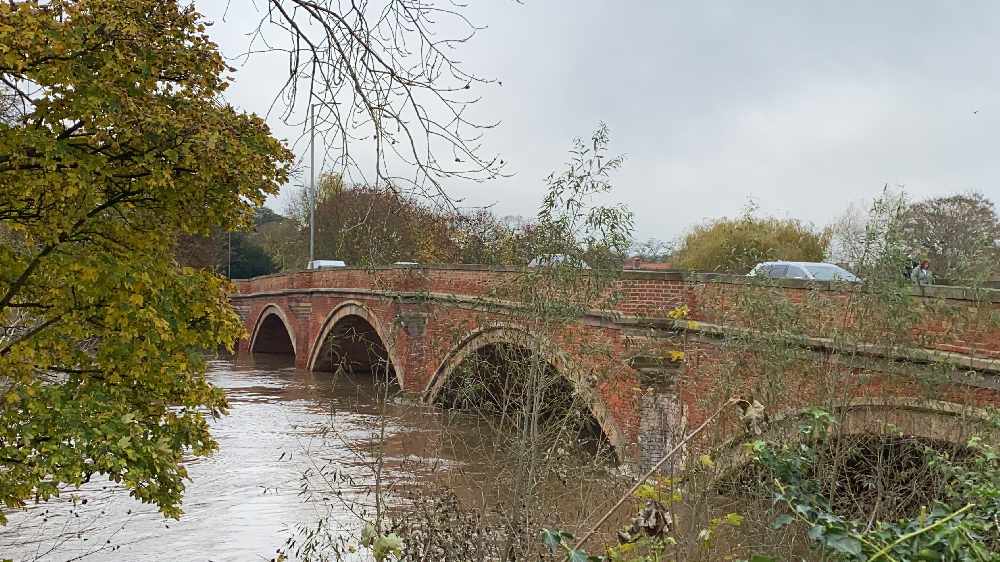
Picture: Kelham Bridge prior to the closure just after 3:30pm
19:00 - Newark and Sherwood District Council are providing sand bags by levels of priority. Anyone who feels they need them are asked to call the emergency team on 01636 650000.
18:04 - The Environment Agency have said river levels have risen at Farndon as a result of heavy rainfall. Consequently, flooding of property, roads and farmland is possible now and until early hours tomorrow morning.
Areas that are most at risk are Newark Riverside Properties. Further rainfall is forecast. We expect river levels to remain high until early hours tomorrow morning.
Also at risk are Tolney Lane Caravan Site and riverside marinas in Newark. Further rainfall is forecast. We expect river levels to rise until tomorrow morning Sunday 10th November
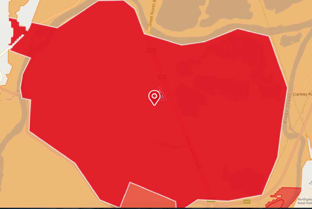
The Environment Agency has said areas also most at risk are the Newark Sugar Factory and Battery including Kelham Lane, Great North Road and Kelham Bridge. Further rainfall is forecast. River levels have peaked and will remain steady, with no further rise forecasted in this area.
17:20 - Newark & Sherwood District Council are strongly advising that residents of Tolney Lane relocate mobile homes to Newark Lorry Park this evening.
A rest centre has been made available for Tolney Lane residents at Newark Sports and Fitness Centre.
NSDC advise if you live on Tolney Lane and need assistance with transport they will be running a transport service from outside Castle House to the rest centre.
The advice for all riverside properties in the district is to prepare for flooding and to let us know about vulnerable people who may be at risk.
If you are concerned about flooding please call our customer services team on 01636 650000.
15:40 - The A617 is now closed between A46/A616/B6326 Cattemarket/Sugarbeet roundabout and Kelham due to rising waters and flooding.
The A1 Northbound between Markham Moor and Blyth has reopened to one lane.
12:50 - The A617 is partially flooded near to Newark Rugby Club
A1 Northbound closed between Markham Moor and Blyth
Saturday 09th November
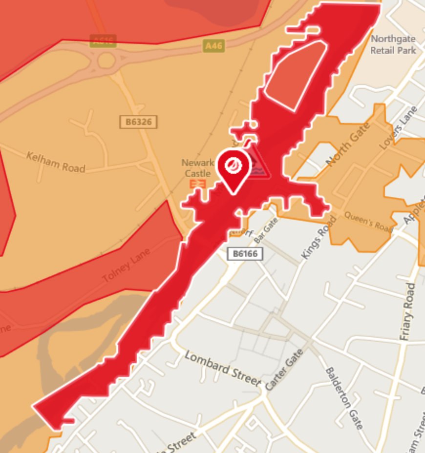
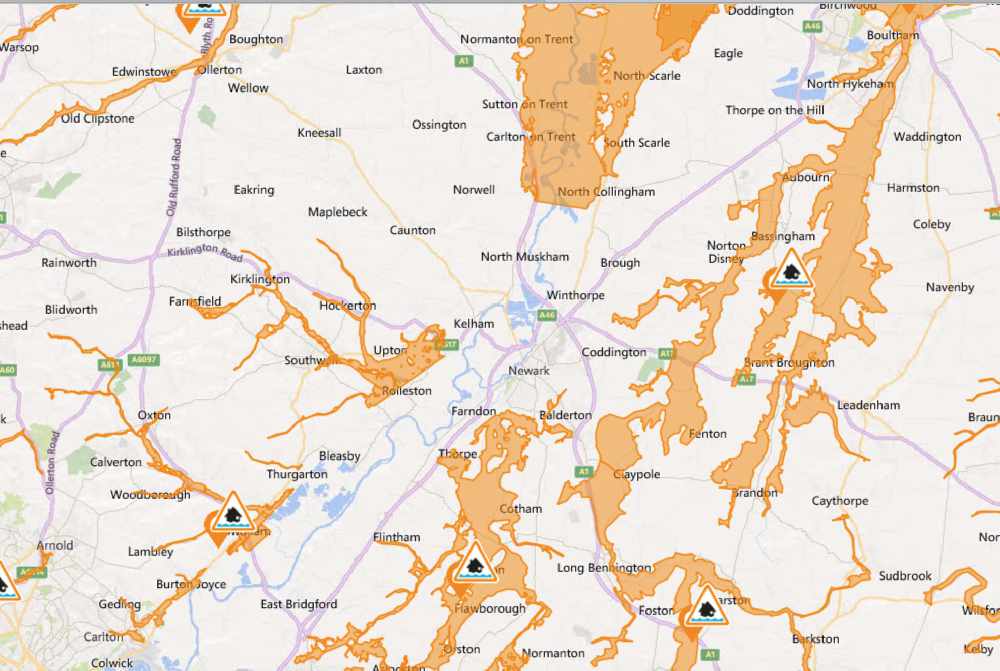
08:56 - The Environment Agency has raised the Flood Alert level to Flood Warning in some parts of Newark. The map below highlights these areas areas.
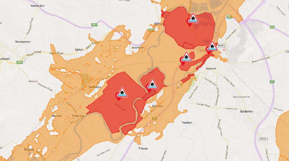
What does this mean?
This means flooding is expected within the red highlighted designated areas. (appear darker orange on this map due to overlaying Flood Alert that is still in force)
Below is what the Environment Agency have said:
River levels are rising at the Farndon river gauge as a result of persistent heavy rainfall. Consequently, flooding of property is expected this afternoon, 09/11/19. Areas most at risk are Newark Riverside Properties. Further rainfall is forecast over the next 24 hours. We expect river levels to remain high for the next 48 hours
River levels are rising at the Colwick river gauge as a result of persistent heavy rainfall. Consequently, flooding of property is expected this afternoon, 09/11/19. Areas most at risk are the Newark Sugar Factory and Battery including Kelham Lane, Great North Road and Kelham Bridge. Further rainfall is forecast over the next 24 hours. We expect river levels to remain high for the next 48 hours
Flooding is expected - Take action
River levels are rising at the Farndon river gauge as a result of persistent heavy rainfall. Consequently, flooding of property is expected today, 0911/19. Areas most at risk are Tolney Lane Caravan Site and riverside marinas in Newark. Further rainfall is forecast over the next 24 hours. We expect river levels to remain high for the next 48 hours.
Flooding is expected - Take action
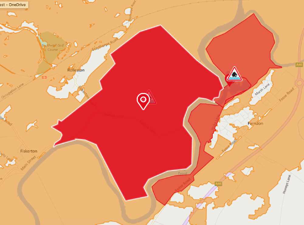
River levels are rising at the Colwick river gauge as a result of persistent heavy rainfall. Consequently, flooding of property is expected this afternoon, 09/11/19. Areas most at risk are Fiskerton Mill, including Rolleston Fields, Gorse, and Nurseries. Further rainfall is forecast over the next 24 hours. We expect river levels to remain high for the next 48 hours.
River levels are rising at the Colwick river gauge as a result of persistent heavy rainfall. Consequently, flooding of property is expected this afternoon, 09/11/19. Areas most at risk are Farndon, including Wyke Lane, Marsh Lane, Farndon Road and Dorner Avenue. Further rainfall is forecast over the next 24 hours. We expect river levels to remain high for the next 48 hours
15:08 - The A1 Northbound between Muskham and Tuxford is now re-open!
14:10 Flood Alert issued for Newark and the surrounding villages. Full details here
14:01- News from authorities say that the A1 between Muskham and Tuxford will hopefully be open around 3pm.
12:23 - A617 at Lockwell Hill has re-opened
Persistent rain in the last 24 hours is causing problems across Newark and Lincolnshire.
Worst affected areas include North Nottinghamshire where 25 properties have been evacuated during the night and further residents ensured they are safe.
Here is what you need to know today before you travel:
A1 Northbound - Closed between South Muskham and the A614 Blyth due to flooding and standing water in the carriageway.
Please follow the square symbol on the diversion route which takes you van the A616 and A614.
UPDATED 09:54 - The A1 is expected to remain closed for the majority of the day as currently more water is flooding the carriageway than can be cleared.
A1M Closed Southbound between M18 and Blyth A614 junction.
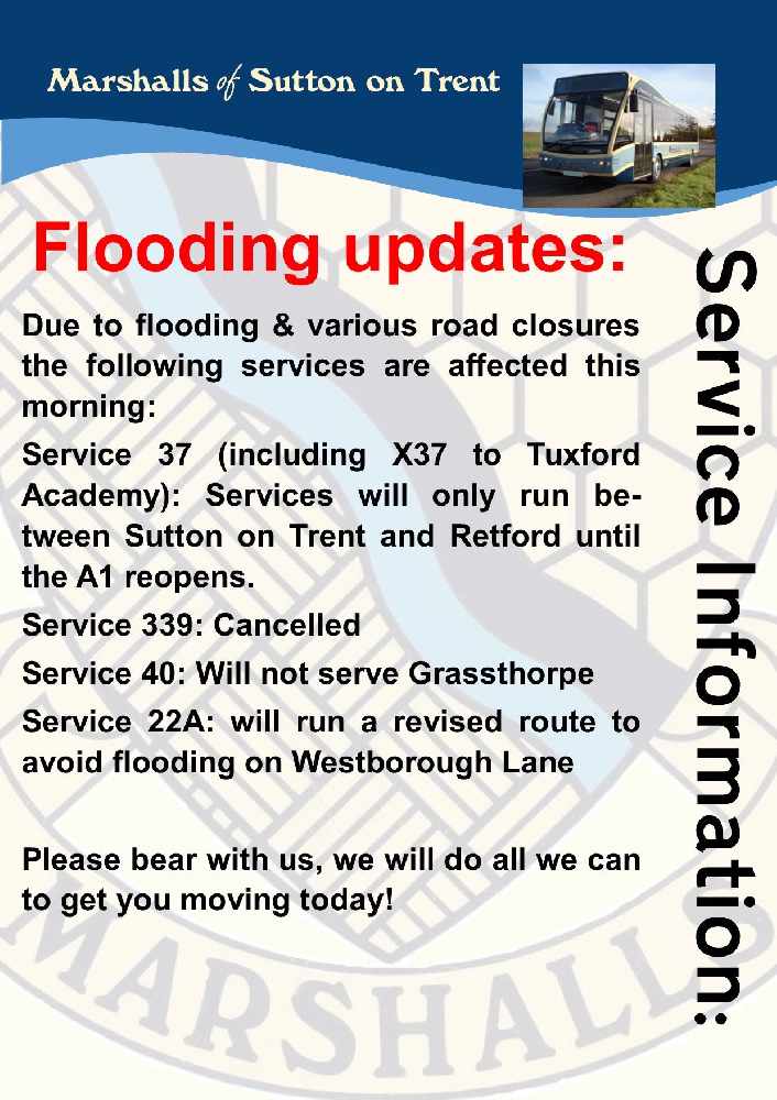
Public Transport:
Marshalls of Sutton on Trent are running revised service.
Travel Wright
Will not be operating service 227 Edwinstowe and the Sutton on Trent Waitrose Shopper
LNER - London North Eastern Railway
Following the heavy rain and rising floodwater the southbound line is blocked between Leeds and Doncaster - as a result services are diverted via Hambleton adding 20 minutes to your journey. Services will not call at Wakefield.
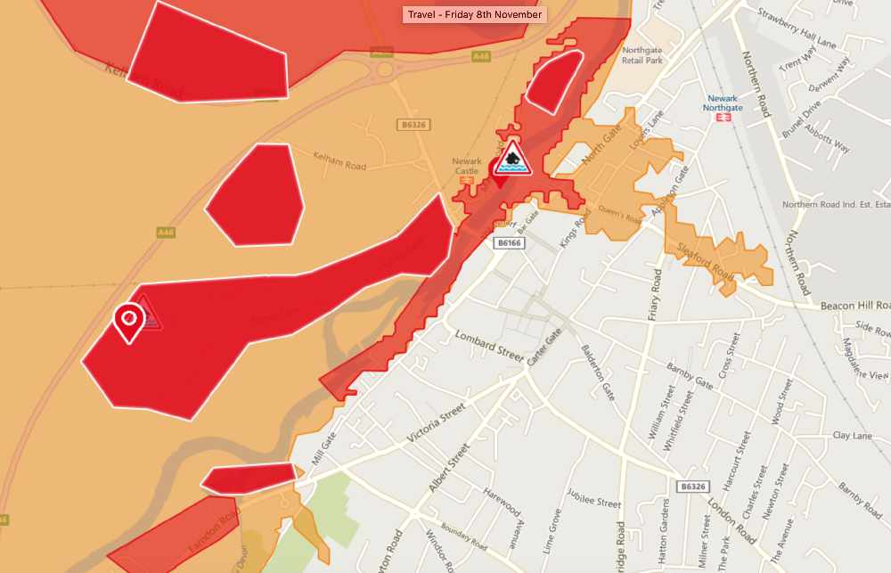
Flood warnings
Flood warnings remain in place across Newark and Lincolnshire.
These are the current affected areas at 08:09 on 8th November 2019
River levels
At Southwell at 4am the River Greet recorded levels of .5m above normal level resulting in flooding being possible low lying land (not properties)
At Farndon at 5am the River Trent recorded levels of .3m above normal level resulting in flooding being possible to low lying land (not properties)
At Claypole at 3am the River With was .7m above its normal range.
At Muskham at 5am the River Trent was within its normal operating range


Comments
Add a comment