


4:48pm
Persistent and fast-moving rain is still expected over the next few days according to the Met Office, this is not likely to be as heavy as was forecast earlier in the week.
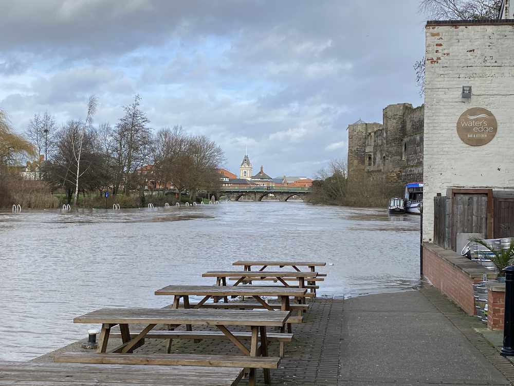
According to the Environment Agency, water levels on the River Trent in Newark have peaked and are not expected to get any higher. Flood warnings for Hoveringham, Caythorpe and Gunthorpe have been lifted.
Multiple flood warnings are still in place for many communities along the River Trent and Newark and Sherwood District Council have distributed aqua sacs to affected properties, with distribution prioritised to those who are the most vulnerable or which are part of critical infrastructure.

9:50am
Update from Newark and Sherwood District Council
Water levels remain high across the district and further heavy rain is also forecast for Thursday.
Residents who are concerned about the risk of flooding at their property should consider evacuating. Anyone needing to leave their homes who can't stay with family or friends should contact the council on the emergency phone line 01636 650000.
Part of Newark lorry park remains open on a temporary basis for residents of Tolney Lane.
Gunthorpe: The flood warning for the village has been removed and the A6097 has been reopened in both directions after water levels receded.
Lowdham: Arrangements are being made for the delivery of 500 sandbags by Nottinghamshire County Council. Heavy rainfall is forecast and residents are urged to make the necessary preparations to protect their properties.
There are multiple flood warnings still in place for many communities along the Trent and Newark and Sherwood District Council has been distributing aqua sacs to affected properties, prioritising our distribution to those who are the most vulnerable or which are part of the critical infrastructure.
Riverside car park remains closed until further notice due to the risk of flooding. Part of the Town Wharf car park is also closed.
The Government has announced a package of support for homes and businesses affected by flooding. The Community Recovery Grant provides the equivalent of £500 per eligible household and £2,500 for eligible small and medium sized businesses and council tax relief, for those which have suffered severe impacts from the floods and that cannot be recovered from insurance. https://bit.ly/2HyrLvV
6:13am
Road closures still in place in Newark area:
- A617 Kelham Bridge to Newark
- Wyke Lane, Chapel Lane - Farndon
- Hawton Road (riverside road to Hawton Village)
- Hawton Lane (Hardy's Farm to Farndon)
- Gotham Lane, Hawton
- Trent Lane, Kelham
- Main Street, Gunthorpe
- Boat Lane and Fiskerton Road - Bleasby
- Shelford Road from Gunthorpe Bridge to Shelford
- Southwell Road - Lowdham
Other road closures in place around Nottinghamshire:
- Kelham Lane, Little Carlton
- Grove Lane/Trent Street - Retford
- Rufford Ford - Rufford
- Harby Lane - Colston Basset
- Kegworth Road & Kingston Lane - Kingston on Soar
- Hall Road & Church Gate - Colston Basset
- Plunger Lane - Granby
- Holygate Lane - Cotgrave
7.30pm
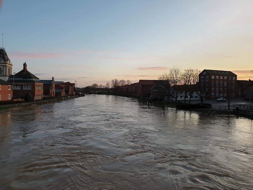
As reported previously, river levels are rising across Newark and Sherwood with peak levels forecast this evening between 9pm and the early hours of tomorrow morning (Wednesday). Environment Agency advice is that these high river levels are expected to be maintained for a prolonged period of between 24 and 48 hours, and that further heavy rain is also forecast for Thursday.
There are multiple flood warnings still in place for many communities with residents in a number of Nottinghamshire villages being advised to monitor flooding risk and prepare to evacuate. These areas include Caythorpe, Gunthorpe, Hoveringham, Shelford, Thurmpton and Trent Lock.
Flooding on Tolney Lane in Newark is continuing and the lorry park remains available for residents with mobile accommodation to relocate on a temporary basis. The Bridge Community Centre will also be available this evening to provide welfare services.
Residents who are concerned about the risk of flooding at their property should consider evacuating. Anyone needing to leave their homes who can't stay with family or friends should contact the council on the emergency phone line 01636 650000.
Lowdham: In anticipation of heavy rainfall over the next few days, Nottinghamshire County Council will be delivering 500 sandbags to the village on Wednesday.
Please check before you travel, and don't drive through flood water. Just 30cm of flowing water is enough to move your car.
1:00pm
Road closures in place in the local area
- Boat Lane - Bleasby
- Shelford Road from Gunthorpe Bridge to Shelford
- A612 & A6097 - Lowdham
- Southwell Road - Lowdham
- A617 Kelham Bridge to Newark
- Wyke Lane, Chapel Lane - Farndon
Other road closures in place around Nottinghamshire
- Blidworth Road - Kirkby in Ashfield
- Grove Lane/Trent Street - Retford
- Main Street - Lambley
- Main Street - Burton Joyce
- Rufford Lane - Rufford
- Main Street - Sutton Bonnington
- Harby Lane - Colston Basset
- Kegworth Road & Kingston Lane - Kingston on Soar
- Nottingham Road - Radcliffe on Trent
- Soar Lane & Station Road - Sutton Bonnington
- Hall Road & Church Gate - Colston Basset
- Plunger Lane - Granby
- Holygate Lane - Cotgrave
12:06pm
River levels are continuing to rise across Newark and Sherwood with the peak levels forecast in Newark this evening between 8 and 9pm.
Newark and Sherwood District Council report their incident response team is continuing to monitor the situation closely and will, along with partners, continue to support affected communities throughout these challenging circumstances.
There are multiple flood warnings still in place for many communities along the Trent and they have been distributing aqua sacs to affected properties, prioritising distribution to those who are the most vulnerable or which are part of the critical infrastructure.
Flooding on Tolney Lane in Newark is continuing and the lorry park remains available for residents with mobile accommodation to relocate on a temporary basis. Overnight around 20 caravans arrived at the lorry park from Tolney lane following yesterday afternoon’s call to evacuate.
Residents in Gunthorpe are being advised to remain prepared as a number of properties and surrounding roads are still expected to flood. Whilst the impact of the flood in the village was not as bad as expected overnight, the water levels in the River Trent continue to rise and flooding remains a risk. The advice comes following Environment Agency flood warnings to people in the area to take action due to the risk of flooding, which is expected to take place in the coming days. Anyone needing to leave their homes who can't stay with family or friends will be able to access a rest centre at Southwell Leisure Centre.
The recovery operation continues in Lowdham and the council is assisting with the clear-up operation. Mechanical sweepers have been sent to the area to assist with clearing away silt and storm debris. We are hoping to have officers on site at the Methodist Church on Main Street from 2pm to offer further assistance, where necessary, to residents needing support.
11:17am
Avoid the area near Hawton and Cotham, roads are impassable.
9:09am
River levels have risen overnight affecting the following areas around Newark:
-
Tolney Lane and Riverside Marinas
-
Newark Sugar Factory
-
A617 Kelham - Cattlemarket
-
Collingham and Girton
-
Carlton on Trent including Beck Cottage
-
Dorner Avenue and Wyke and Marsh Lane in Farndon
-
Fiskerton Mill including Rolleston Fields, Gorse and Nurseries area
-
Gibsmere and Gipsy Lane at Bleasby
-
Hoveringham
-
Caythorpe
-
Gunthorpe
Patrols are in place to monitor with riverside residents being advised to move to a safer location.
9:03pm
NSDC announce that Riverside carpark will remain closed throughout Tuesday and that motorists should use alternative car parks within the town.
8:30pm
River levels at Farndon are increasing and are nearing the level of 2012.
6:55pm
Further Flood warnings have been issued and are now in force for the following:
- Carlton on Trent including Beck Cottage
- Girton
- Collingham
- Main Street and Caythorpe Road near Moorfield Farm, Caythorpe
- Boat Lane, Gonalston Lane and Main Street, Hoveringham.
- Shelford Manor
The following Flood Warnings remain in force:
- The Sugarbeet Factory, Kelham Lane, Kelham Bridge.
- Properties that are Riverside along the River Trent
- Tolney Lane, and Riverside Marinas
- Wyke Lane, Marsh Lane, Dorner Avenue and Riverside properties.
- Fiskerton Fields, Rolleston Fields, Gorse, and Nurseries
- Bleasby and Boat lane at Gibsmere
- Gunthorpe
Flood Warnings indicate flooding can be expected to low lying land, properties and farmland. They are not risk too life warnings.
6:00pm
Nottinghamshire County Council have released details of a hardship fund for flood victims.
Residents whose houses have flooded can apply for a payment of £120 and small or micro businesses with up to 49 employees, whose premises were flooded will be eligible to apply for an emergency payment of £300.
Find out more in our article here
Here is your latest update on the flooding around the area.
3:00pm
Newark and Sherwood District Council are advising residents of Tolney Lane caravan site to evacuate the site. The Lorry Park on the Great North Road (Cattlemarket roundabout) will be available for residents with mobile accommodation to relocate on a temporary basis.
This is due to rising flood waters on the River Trent.
2:40pm
Flood Warnings remain in force for the following areas:
- The Sugarbeet Factory, Kelham Lane, Kelham Bridge.
- Properties that are Riverside along the River Trent
- Tolney Lane, and Riverside Marinas
- Wyke Lane, Marsh Lane, Dorner Avenue and Riverside properties.
- Fiskerton Fields, Rolleston Fields, Gorse, and Nurseries
- Bleasby and Boat lane at Gibsmere
- Gunthorpe
Flooding on riverside properties and low lying roads and farmland is expected.
A Flood Alert remains in place for the majority of the land around the area of the River Trent.
Light rain is forecast for the next 24 hours with heavier spells of rain forecast for Wednesday and Thursday.The Environment Agency, Newark and Sherwood District Council and emergency services are continuing to monitor the situation.
It is requested if you live in the above areas you move any valuables, insurance documents and medicines to a higher ground.
Road closure:
The A617 remains closed between the Cattlemarket and the Fox Inn at Kelham.


Comments
Add a comment